Showing posts with label bike packing. Show all posts

Tuesday, January 30, 2024

Huracan 400 Ride Report -- Day 1


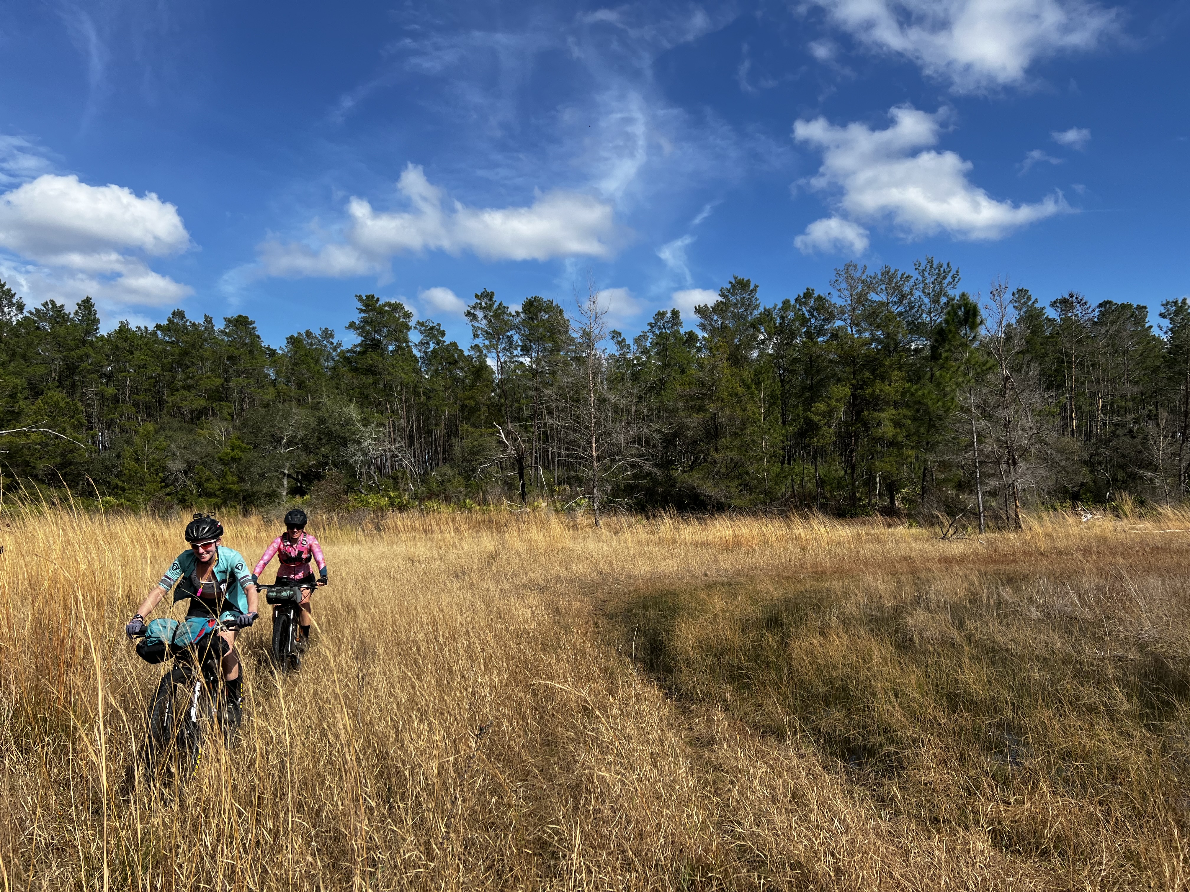
Summer kits in January!

Our day began with a 5 am wake up call, followed by several cups of Sleep Inn coffee ... meh! After throwing the gear we would not be taking with us into my truck, I said a silent prayer that Biggie G would not be violated during our 3 day absence. We pedaled 6 miles to the start of the course, praying once again that we would not be plowed by rush our traffice ... at 6 am!  


Nayls North Trail

The weather was very pleasant starting out at a cool 65 degrees. Going clockwise we rode about 25 miles of Santos single track, stopping at the campground to refill our water.  From there it was more single track over to Marshall Swamp.  The Studebakin Trail should be renamed Rodeo, as it was very lumpy and my bike felt like a bucking bronco beneath me.

There was a beautiful paved path lead in to Marshall Swamp.  The single track through the swamp I thought was in excellent shape, with a few sections of pedaling through water.  We then rode a short section of the Florida Trail before dumping out onto some paved roads.


Marshall Swamp


Marshall Swamp


At 54 miles into the ride, we stopped at the Solid Rock Church (mile 48 on the course) to filter water from the spigot (said non-potable).  I dropped an electolyte tab into my bottles, but it still tasted like ocean sand.  Soon after that stop, we rode some beautiful limestone roads, only encountering a brief stretch of sugar sand.  It was easily rideable as it still contained some moisture from last night's rains.


Fast as asphalt

Not as bad as it looks

We entered the Ghost Trail at mile 69 (mile 63 on the course). 3.5 miles of trail that was either covered in blow downs or overgrown with grass.  This trail skirted around the northwestern section of Farles Lake. The views were eye candy!  The water was down, so we were able to skirt around the fallen trees and ride close to the waters' edge, where the dirt was firm and the grasses shorter

.

Ghost Trail


Ghost Trail


As our water was running low, we stopped at Farles Lake Recreation Area.  The water pump was broken, so we filtered water from the lake.  That was the best tasting water of the whole ride!  The heat of the day was now upon us (82 degrees).  I thought I had been drinking enough, but started getting a head ache, so I took a couple of extra strength Tylenol.


Farles Lake

More miles of limestone and pavement brought us to the Paisley Mountain Bike Trail: 11 miles of open, flowy, and hardpacked sand/dirt which was very similar to Croom.  I was ready to be done by the 7th mile as it was getting redundant and I was low on food.  Fortunately, the town of Paisley was just a few miles beyond the end of that single track.  


Slim pickens for me


Lisa and Lindsey headed inside while I watched our bikes.  There was a sketchy dude on a clapped out Specialized CrossTrail that pulled in just as they went inside.  Glad I opted to be watch dog because I could see this dude eyeing our bikes pretty hard.  He didn't seem like the serial killer type so I talked to him and tried to tighten his handle bar, but the bolts were completely stripped.

I made due:  1100 calories


Leaving Paisley, we encountered Maggie Jones Road, of which I have heard nightmares.  Today we won the lottery, as it was hard packed and fast!  

Gopher tortoise on Maggie Jones


More fast pavement took us to Seminole State Forest.  Here, we were supposed to pay a day use fee of $2.  I had brought plenty of dollar bills to deposit at the pay station, but you had to use your phone to pay online.  After 10 minutes of attempts, including the website locking up on me, I said, "Fuck it, this is ridiculous!"  Even though I was not in racing mode, I did not want to waste precious minutes of daylight.  I wanted to just drop $2 on the ground and go.  (I later paid online, when I got back home and could do it without any stress.)

The roads through Seminole State Forest were beautiful. The sun was beginning to set, temperature was cooling down, my headache was gone, and the King Size Snickers was in my belly.

Seminole State Forest

Rock Springs Run was 8 miles of hell!  It started out with firm double track which soon became swampy with many boggy areas that involved pushing through or around deep water.  And then night fell. 

There was a short section of GPS track that had us deviating off the double track.  We quickly decided to follow the shit road we were on instead of bushwhacking deeper into hell.  That cost us a few minutes and some tears.  And then there was the Challenge Trail, aptly named not due to technical features, but because that it was completely overgrown with underbrush.  Our poor bikes and legs were lashed almost to death. I kept getting small sticks and vines wrapped around my cassette.  Our bike derailleurs were lucky to have survived.

What trail!?!

At 8 pm and 128 miles (122 miles on the course), we made it to the short rogue trail down to the  Wekiwa River crossing.  I was glad I had watched a few YouTube videos on daylight crossings. While Lindsey and Lisa were hem hawing, I saw the little strip of water on the opposite side, hoisted my bike on my back, and began the 40+ yard journey.  The water, being spring fed was warm, and it got no deepper than just above my belly button.  I could hear Lisa behind me as she began the crossing, telling me not to get any pictures as she was naked from the waist down.  As I made it to the other side, I could hear Lisa saying, "Where's the line?  It's tits deep!"  I was laughing so hard, I had a hard time getting my phone out to take a photo or two.


I have finished my crossing and this shows the long approach up the little inlet to the boat launch.


The light in the distance is Lisa and Lindsey

Even though Lisa took off her shorts to keep them from getting wet, she still managed to get them soaked.  We took a few minutes to gather ourselves while Lisa got dressed, and then began riding up the road.  Just around the corner no more than 30 yards from where we had crossed, were some campers around a fire.  They were probably caught off guard a little, seeing and hearing us 😂😂😂 coming out of nowhere ... on bikes.  We got a good belly laugh out of that!

We were now in Wekiwa Springs State Park on 8 miles of wide single track.  Heading out of the state park, it was now almost 9 pm.  We made a mad dash to the Publix on Wekiva Springs Road, but they had just closed when we arrived.  So then we went to the Publix on Hunt Club Blvd, as we found out they stayed open until 10 pm.  Here we grabbed some subs and bike food for Day 2.  


Needless to say, we got some strange looks.


We ended up rolling in to the Holiday Inn around 10 pm.  I was able to shower, eat, do a load of laundry, stretch, clean/relube the chain, and get to bed by 12:15am.  Man, what a day!

141 miles total, 131 miles on course, 3500 feet of gain, elapsed time 15:41, moving time 13:50.


Monday, July 4, 2011

TNGA Recon

With the TNGA only 2 months away and I being a bike packing virgin, I decided to pull an overnighter on a section of the course.

At the start


I began my adventure at Moccasin Creek State Park at 8 am.  My bike and gear weighed in at a hefty 45 pounds.  That is 41% of my body weight!  Having never ridden with weight like this before, I immediately felt it ... even on the beginning flat section of asphalt.  Climbing up the Wildcat Creek forest service road gave me a chance to get used to the weight and how it was distributed on the bike.  I think I packed Stumpy, aka The Yak, pretty good, as the bike felt balanced.  The downhills took some getting used to, especially the tighter turns.

The morning hours were quite pleasant with the forest service roads offering plenty of cover from the sun.  I was just at a cruising pace and had planned to make Helen by 11 am.  But ......  then I made the approach to Hickory Nut Trail.  I looked for it for several minutes, first going to the right and then to the left on trails that led nowhere.  I then came back to the intersection, switched my GPS from breadcrumb trail to compass.  The cue sheet said proceed around dirt pile and head south.  So I did and entered the bushwack from hell!   Poison ivy, poison oak, and blackberry briars greeted me.  Nice!  I finally found a resemblance of trail, only because of the wild hogs that had cleared some small sections looking for breakfast.  The next 2.5 miles was a combination of pushing, soft pedaling through derailleur-eating sticks and large rocks, hoisting Stumpy over downed trees, and hoping no copperheads were lurking in the thick underbrush.  A few choice words were said, including "tartar sauce!" and "pickle juice!"  (Carly has taught me well.)

The last mile of the trail was rideable but not what I would call fun.  Those 3.5 miles took an hour to get through!  And then I had to stop at the lake, remove socks/shoes and scrub the ivy/oak resin off my legs.  Was I ever glad to get to Wendy's!  Although I had to wait in line due to the lunch hour rush, it was worth it.  The last time I had a Wendy's burger was after the 2006 12 Hours of Oleta in Miami, Florida.

Hunger satisfied, I began the long pedal up Hogpen Gap.  This is a 7 mile paved climb, with grades ranging from 8-15%.  Pedaling a fully-loaded mountain bike was a far cry from riding a 16 pound road bike during the 6-Gap Century!  From there it  was a 4 mile descent to my next turn.  As I began my descent, my speed approached 40 mph.  As I came around the second sharp turn, there stood a mama bear and 3 cubs!  I had nowhere to go and could not stop.  I managed to wrestle the bike to the middle of the road and just as I became even with the bears, she jumped over the guard rail and the babies followed.  Whew!  That could have been ugly.

The remainder of the day was anti-climatic, just turning over the pedals while a steady drip of sweat fell from the tip of my nose.  I was happy that I had chosen Stumpy with 120mm of travel, fore and aft.  I call her my "recliner" bike and felt comfortable all day.  Some of the fire road descents were pretty eroded and rocky, but seemed effortless and fast aboard my full-suspension steed.

After 11 1/2 hours, 95 miles, and 10,500 feet of climbing, I found a nice spot along the Toccoa River and set up camp for the night.  The ThermaRest Neoair pad, size M (14 oz) was very comfortable and the Kelty Lightyear down 40 (11oz) kept me warm when the temps dipped down to 60 degrees.  Yes, at about 3am, I got cold and had to burrow into the bag.

The next morning Loretta joined me for the ride to Mulberry Gap.  We got moving shortly before 8 am and the Aska trail system was the first real bit of single track that I encountered on my HEAVY bike.  A bit more pushing was involved and it was harder to steer through the switchbacks.  Amazingly, my legs felt great and I was able to ride more than I thought I would.  My body had finally adapted to The Yak.  The descent off Stanley was fast, but not screaming XC fast.

Loretta and I refueled at the small grocery just before the climb up to Watson Gap.  Unfortunately, this store won't be open when I come through during the race.  This section from Shallowford Bridge Road to Mulberry Gap is devoid of stores.  It will be imperative to find water to purify (easy enough) and have enough food on board to make it without putting myself into a deficit.  At least on this section Mulberry Gap will be my carrot.

Mulberry Gap food!


The South Fork Trail was chewed up by recent horse traffic.  We encountered a group of five horses, but the people were very congenial.  Surprisingly, if you just use common sense and give the horses and their riders respect, you come to find out that they are mostly good people. 

The climb up the remainder of Potato Patch from Buddy Cove was brutal.  It was here that I hit my lowest point of the ride as I had expected a short journey from the Pinhoti to the 3-way intersection.  Fortunately I had drunk a Red Bull which helped to see me through.

It gave me eagle wings, but I was really needing condor wings at this point.


We finished up our ride with the Bear Creek descent.  We opted to skip out on the P1 and P2 as time was getting away from us and we both had families that were expecting us home soon.  Mulberry Gap was fulfilling, what with a hot shower and Ginni's cooking.

A PR for Loretta ... longest MTB ride, ever!

We covered 61 miles and 7500 feet of climbing today.  This was a great test for both my gear and myself.  I felt sparkly the whole way, save for Potato Patch.  This also had been the longest I had been on the bike this year.  If I can keep my bike and body working well and the weather is good (meaning hot and dry), the TNGA is definitely doable ... and perhaps winnable!

My hands held up well, but I think I will swap out my Ergon GC2's for the GS2's.  With the GS2's having a slightly longer bar end and with the grippy rubber, my hands and ulnar nerve will be happier over the long haul, especially if I get wet during the race.

The Chamois Butt'r 1oz packets did their job well.  No chafing/sores, but I still had some sit bone soreness after the ride.  I suppose the only way to fix that is to ride more ... which I can do.

I had so much fun than another bike packing session is being planned for late July.