Saturday, April 24, 2021

Dirty 130 ITT Race Report


This route, designed by Kim Murrell, is one of three races hosted by Tennessee Gravel.  This year it is happening as an ITT event, which I kind of like, because I got to choose my date, ensuring that at least I would not be out in the rain.  But not wanting to do it alone, I invited my Rescue Racing team mate, David Jolin, from Ohio.  A race of this magnitude would be much more endurable with a friend to share the highs and the lows.


We managed to start a little before 6 am.  The temperature was 40 degrees, but we warmed up quickly as the first 10 miles was all climbing. Knowing this route, I had not turned on my navigation, in order to conserve battery life.  We went by where the Great Pyrenees lives.  He barked but did not give chase.  My one and only navigational error came at mile 2.5, where I proceeded straight up the hill (Chestnut Mountain Road), as opposed to going slightly left onto what would turn into FS68.  My intuition immediately kicked in, but I stupidly chose to disregard it.  I turned on my navigation then, but it was confused and so I wasn't getting the "off course" message.  A half mile later, I finally realized the error, we turned around, and got back on track.


The sun began to rise as we approached the top of the climb.  As we headed on to FS 80, I stuffed a banana into my mouth.  No enjoying eating here because of the harshness of the terrain and it soon began going downhill.  This 6 miles of mostly descending was super chunky what with the embedded rock and several wash outs.  I descended cautiously, as I did not want to flat.  What warmth I had obtained in the previous climb completely left me about halfway down. Because I have Reynaud's, my fingers and toes became painfully cold. With extremities that felt like cinder blocks and eyes watering so badly I could hardly see the road, it was a miracle I stayed upright.  When I turned right onto FS 23, the descending and the misery continued. All I could do was endure, knowing that I would eventually warm up.  I was frustrated as I knew I could go faster, if I just wasn't so friggin' cold.  Garmin was registering 36 degrees.

Left onto FS 103, and my body slowly began to warm up. Climbing never felt soooo gooood!  The re-freeze began on the next descent down to Lost Creek.  Climbing out of Lost Creek, my little reptilian body began to feel the warmth of the sun, and I was almost done with this freeze/thaw situation. Hitting Hwy 30, I was finally 100% warm again and relishing life once more. Although I could have done without the 60 minutes of being miserable, it's this hard shit that makes me feel alive and so appreciative of the "easy" parts.


We stopped at Webb's Store for a pee break and bottle refill.  It was here that I enjoyed one of my rice cakes. Although the air was still cool, the sun's rays beemed down into my soul.  Pedaling on Hambright towards the creek crossing, a very aggressive pit bull mix shot out of the yard right where the road ended and the ATV double track began.  Fortunately I had just enough momentum to get around him before he latched onto a body part and just enough "runway" left before I had to brake hard to avoid the overgrown trail.  


We stopped at the creek to take our socks/shoes off and wade across.  Although there was a perfectly good railroad trestle over the river, it was off limits. This ate up a good chunk of time as we had to dry our feet and brush all the sand off.  But well worth it, as my feet would have been popsicles had I waded through with shoes on. At this point in the day (9:30 am) it was still in the mid-40's.

Knee deep for me, mid calf for David


Praying my foot would not find a fish hook or broken beer bottle.

After negotiating the multiple mud holes after the crossing, we hit the flat gravel section back to Hwy 315.  I had managed to get my shoes a little muddy in the process, but the annoying Sponge Bob sound I had been hearing like a metronome with each pedal stroke for the past 35 miles mercifully went away.  About the only time that I have been happy I sunk my shoe in mud.


FS 44

The Starr Mountain gravel was in primo shape.  It felt that we were through that section and sailing down the pavement to Hwy 315 in no time.  The sun was shining, the last of the bone-chilling cold left me, and my pistons were firing quite well.  The next 10 miles, on pavement, included Ivy Trail, Towee Falls, Epperson, and Hotwater.  It took almost just as long to ride those paved miles as it did the Starr Mountain gravel.  Some of the steepest grades of the day are on Ivy. The same dog gave chase on Towee as it did back in 2018.  But this time it's owner was not firing up its shock collar. Fortunately its aggression had mellowed, and deemed us not worthy of any extra calorie expenditure.


Enhanced rollers between Hwy 315 and Hwy 68


Although the Coker Creek visitor center was closed, we still stopped to take a pee break and eat another rice cake.  Looking at the elapsed time, I knew that today was going to be more than 12 hours, which what David had said in the previous week he was shootin' for.  I thought that his time was ambitious, and secretly I hoped it would be 12 1/2 hours of total time.


I was hoping to meet Zeke along the flats of Shuler Road, but we ended up seeing him on the descent off of Unicoi Gap.  We stopped briefly and I introduced the OG's to each other. The conversation was interrupted by a truck coming down the gravel.  Not wanting to get caught behind it on the descent, I told the guys that we needed to mosey along.  Zeke was doing hill repeats so he continued on up to the gap, while David and I cruised down to the flats of Shuler Creek.

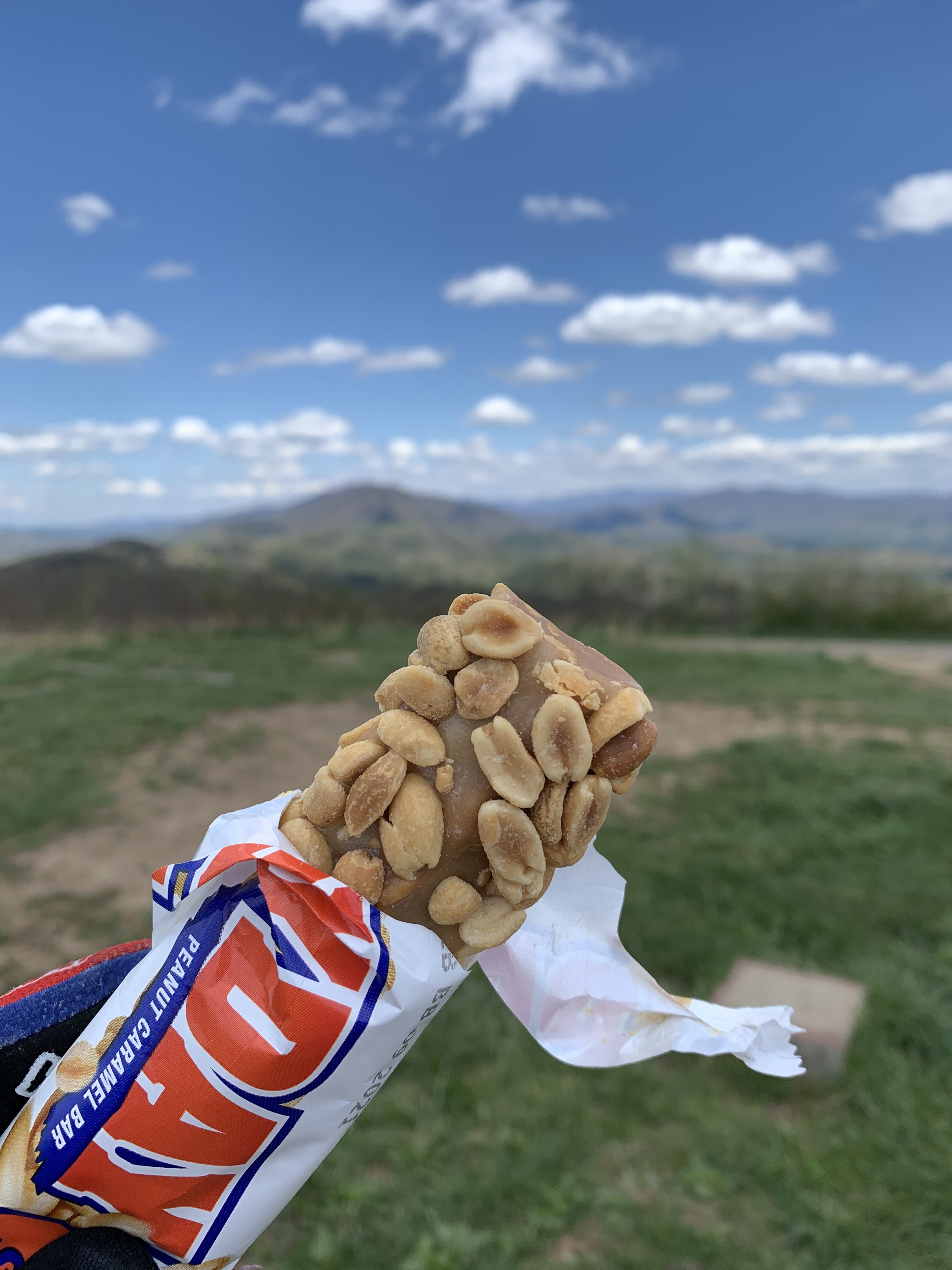
We stopped at one point to filter water and I ate my last rice cake.  The remaining 7 miles before the Buck Bald climb, I tried to take it easy and spin a higher cadence because I knew one of the toughest climbs was about to begin.  Being 78 miles in, although the spirits were bright, I was feeling the fatigue start to set in.  1000 feet of mostly rugged double track in 5 miles; I set my mind to thinking about enjoying that PayDay up top and showing David the stunning view.  Half way up we were passed by 6 dual sport riders.  I thought to myself:  betcha we were covering more distance than they today! It was karma that at the top we videobombed the dual sport riders beginning their descent off the bald.


Buck Bald reward!

How many people get to enjoy a one of the best ride candy bars on one of the most beautiful balds in the Southeast?  We took several minutes to soak up the view and just appreciate life.


Caption this 😆😆😆


This guy:  so fortunate to have met him at the 2017 Marji Gesick.

The road back down to Hwy 68 had deteriorated since 2018.  The forest service must have put fertilizer down because the embedded rocks had grown tremendously.  Even though I wasn't going all that fast, I still managed to bang my rear wheel on one, which gave me a moment of concern.  Fortunately the tire held. A brief respite on Hwy 68 and then the cursed dog alley on Bailey.  As the big dog gave chase, the owner called out, "He is just wanting to play!"  Seriously?!?  

As the pitch steepened to 14%, I knew I was about to enter the "world of hurt." Why does time always seem to come to a crawl when the pain intensifies.  Over the next two hours, from Bailey Road to the top of the FS 236 climb (20 miles), I was a hurtin' buckaroo.  There are always lows in these races, but I do believe this was one of the longest ones.  I did have a brief respite when I crossed paths with Eddie O'Dea and Audrey Tanguye on Powerhouse, who were out for a 3 day bikepacking trip.  I stopped momentarily and talked with them.  Seeing their fully loaded bikes, I scolded myself for being a wuss.  Seeing them was exactly what I needed to regain my focus. I pulled out a caffeinated Clif double expresso gel, took a hearty dose of liquids, and kept a slow, but smooth pedal stroke up the FS 236 climb.

Eddie and Audrey

That climb was brutal, but I just kept telling myself that there was only one climb left.  Not to mention how loose the gravel was so that I could not even stand without the rear wheel spinning out.  For a large portion of the course, I do believe the graders had come in over the winter and just scraped up all the shit in the ditches.  At first when my energy levels were high, it was just bothersome.  But not as my fatigue grew, it was becoming evil! 

Even though there were 25 miles left, I told myself just 15, as the last 10 were all downhill.  I was trying to stay positive, even though the most heinous of climbs loomed ahead. Cresting 236 I inwardly screamed for joy.  Two tasks left:  find the piped spring and finish off the last climb.  The piped spring came at mile 108.  So ... dang ... refreshing!


No need to filter.

David had been a beast all day.  He would stand and hammer quite a bit on the climbs and never once had anything bad to say.  The perfect partner.  For the most part we stayed in our own little bubble, he always slightly ahead, but never out of sight. He paced off of me, never straying too far or going too hard.  

This last climb, I finally got my shit together, and felt strong again.  Perhaps it was the caffeine shot, perhaps I was smelling the barn, but I hit this 10 mile climb with renewed vigor.  Retired Navy Seal David Goggins, who always says you have more in you to give than you realize, popped into my mind and kicked the monkey out.

    "When your mind is telling you that you're done, that you're exhausted, that you cannot possible go any further, you're only actually 40% done."

I crushed that mountain (second fastest time out of the 4 times I have done this race). Once I hit the rough embedded double track section (McFarland Road) with grades approaching 18% at times, I shouted out expletives, not in anger, but to empower myself, willing myself to fly.  For once I took the lead, trying to pace David up that climb, as he now entered his own pain cave. That was exhilarating!  Once off that embedded rocky road, we had about another mile of smoother gravel before the final descent.  Although the sun was still up, we were now on the shady side, and I could feel the coolness in the air.  I was hopeful I could make it to the finish with plenty of daylight and warmth in my body.

I believe I used up most of that "60 %" I had left at the beginning of the climb.  Because ... that ... 10 ... miles ... of ... descending ... was ... the ... most ... miserable ... I ... have ... ever ... felt ... on ... the ... bike.
The rough road had my body vibrating so hard that I thought my eyeballs and teeth would yard sale.  And then I got cold.  And then I got nauseous.  And when I got light-headed, I had to stop and rest a couple of minutes.  During this period, I could feel my body "hum" with vibrations like a tuning fork.  Back on the bike to endure a few more miles of torture.  Stop again before I pass out.  God, just get me to the pavement!  David had gotten ahead of me on the descent but every so often, he would stop and wait for me. 💓

I was so happy to hit the couple of short climbs during this trek down off the mountain.  My head would clear and my legs worked out of the saddle, feeling like I was starting fresh again.  Finally the pavement and I could relax a bit.  The Great Pyrenees gave chase when David went through; I was about 30 yards behind.  The dog saw me and came within inches of taking me down as he charged towards me.  Whew!  I was thankful for that little bit of good luck, as that woulda no doubt caused some carnage to my body and bike.

We pulled up to my truck after 13 hours and 20 minutes (12:20 ride time).  I could barely throw a leg over my bike to get off.  We both sat on the tailgate and just watched our bodies shake in shear exhaustion/cold.  Damn!  What a day!  I don't know about David, but within 5 minutes, I was thinking of how I could improve on that time when I do it again 😂.  Despite feeling absolutely shelled not 30 minutes prior! Crack head!


Thank you, David, for one helluva day!  At least this time, I did not pass out post ride.  I am looking forward to our next adventure.  Thank you Kim for one beast of a ride and tennesseegravel.com for creating the platform of healthy competition.  Now, where's that pizza!


Sunday, April 4, 2021

Tour de Liverance Ride Report


Post ride feels!


It all started with a simple FB group message from Monica.  She was gonna ride the intermediate course of Corvus Racing's Tour de Liverance.  I bit.  From there it morphed into a group of 5:  Monica, Lindsey, Farmer G, John, and I.  We decided to let it warm up a bit and began at 10 am.  This "race" was an OYO format.  A GPX was provided, but nothing else.  But there were multitudes of churches and running water for refills and a couple of C-stores, too.  

The course was 79 miles and 6500 feet of elevation.  Although I had put in some hard hours at the gym this week and knew I would be carrying some muscular fatigue into the ride, I still figured on a 6 hour ride time.  I brought 1600 calories and started out with 3 bottles, 2 filled with Skratch, and 1 with my Infinit Nutrition Triple G formula (200mg caffeine, baby!).

Punchy AF climbs ... all day long!

The beginning miles were pretty mellow and paved.  At mile 2.6, the first climb (on Flat Branch Rd -- misnomer) was at a punchy 10% grade and almost a mile long.  Needless to say, despite the 42 degree starting temp, I was no longer cold.  The first section of gravel was Wolfpen Gap at mile 8.  This was absolutely beautiful. At one point, along a flattish stretch, something made me turn around and look back.  I saw John leaning over his bike and my first thought was that he flatted.  I turned around and rode back to him.  When I got closer, I saw his bottles scattered across the road.  Uh-oh, that could only mean one thing: he took a digger.  He is going to have to work on his photography skills while avoiding pot holes. Fortunately it was only his ego that took a beating. A few minutes later, we got rolling again.

The smooth gravel soon morphed into a technical rocky Jeep trail (Harper Creek).  What with the 3 inches of rain in the few days prior, the trail was fairly water logged.


My element

Even though my legs had already started whimpering on that first road climb, it was here that I found my groove and the legs sprang to life.  I suppose it was the focus I was giving to the trail that diverted my attention away from my legs.


Lindsey "all the watts" Kenney


First of several enhanced sections


After a wickedly fun descent that dropped us out on Gates Chapel Road, we hit GA52 for a short bit to connect us over to about 10 miles of pavement leading back to Ellijay.  Mostly easy rollers, until we got to the "trailer park" climb, a section of rough pavement that seemed to go straight up, 19% at one point.  I was thinking to myself, "How the hell did they get all these trailers up here?!?"  The backside of this hill made for a much better approach in getting the tornado magnets to their destination.  Oooof!  That was one heck of a kicker!

The short section on Main Street was the scariest part of the day, as all sorts of humanity were out running the roads.  I about had my head taken off by a redneck pickup side view mirror!  Jesus!  As we worked our way over to Talona Mountain, this is where the wheels began to fall of the bus for me.  Even though I had not been doing much pulling on the road sections (Lindsey, with all her road watts, did the bulk of it), my perceived exertion in the draft was a 7-8/10.  This is where it began to get real for me and the mental game began.  But I had expected this, knowing what I had done during the week, and was ready to grin (grimace) and bear it.  I have the Dirty 130 on the calender in a few weeks and just needed to work on my mental toughness a bit.

Although the out and back on Talona Mountain was paved, it was still a SOB!  It reminded me of the straight up climbs at La Ruta.  This road would be perfect for prepping for this stage race!  At almost 2 miles long, it averaged 8%, but felt a lot more like 15%, what with several 19-20% kickers on it. I did stop half way up because I fell in love with this house.  This is my style of a retirement home.


Would kill for this house plan!


By the time I reached the top, everyone else was finishing up their picnic.  I hurridly pee'd, took some pics, fed my pie-hole, and hurried back off the mountain at a 43 mph top speed.


The view atop Talona


Take your pick:  Christ or 5G?

I was glad that the following 6 miles were slightly downhill.  It gave me some time to digest my little lunch and allow the legs to recover.  I had to shake the thought that I was only halfway done out of my head, lest it get the best of me.  The monkey was going to get some duct tape if it didn't shut up!

The next 10 miles were a mix of rolling paved and gravel country roads.  We were entering the heart of North Georgia wine country.  We crashed a wine tasting party at Chateau Meichtry looking for water.  After refilling our bottles, we continued on similar terrain for another 12 miles.  


Wine Country


Although we had made a couple of wrong turns early on in the course, now as we were probably all feeling the effects of 50+ miles in our legs, the wrong turns seemed to be increasing in frequency.  As I was not in the lead much, I had the lemming mentality and did not watch my Garmin screen as judiciously as I should.  Somehow we managed to end up at the washed out culvert bridge on Hill Road that the race promoter had changed the GPX tract so that we would avoid this.  So we had to climb back out of that steep descent and then got off course a few more times before finally getting it right 🤦.


Gap Jump

During one of our pee breaks, we met a young girl, probably 10 years old, on the coolest purple bike.  Her name, to beat it all, was Cadence.  She was riding alone, up and down on a short stretch of gravel.  Her Mom was sick with some sort of stomach virus.  She asked if she could ride with us.  My heart almost broke. So innocent and just wanting to hang out with people that were doing the same thing as she.  We talked to her for a while but then sadly had to part ways.

I am slowly realizing not to follow those who use a Wahoo GPS.  Or it could be the user 😆.  For whatever reason (and I have never used one nor seen one), but it appears that the breadcrumb trail is not as accurate as a Garmin??  Monica and I had to redirect John and Greg a few times after they missed turns.  But, to give them credit, some of these turns were pretty obscure, as it appeared that they were no more than a sketchy drug use or "Lover's Lane" area.


Roston Road, which started out as a sketchy two-track, but opened up into this beautiful stretch.

The second scariest bit of road was Hwy 52 near all the orchards.  It was just a 1/2 mile stretch, but traffic was super thick.  We meant to stick tight to one another, but John took off like a rocket, and my legs seized, immediately popping me off the back.  I slow pedaled and made it without becoming road kill.

Around the 65 mile mark, Greg was ahead but then immediately slowed and stopped.  As I approached, I saw that his rear wheel was flat.  I reached for my tire plug kit, but then he said the four words I did not want to hear, "I don't have tubeless."  A small part of me died.  I wanted to fall to my knees, lift my hands to the skies, and shout, "Noooooo .....!"  You see, I had been in this situation before with another friend last fall during a gravel ride.  His name will not be mentioned.  We all survived and made it to the finish, but it was an event in of itself.  

But I stayed positive.  We would be up and running in 5-10 minutes.  Well, 40 minutes and two tubes later, we got moving again.  But my legs went on strike.  That was a painful restart, but I just kept telling myself it is all part of the bigger picture of gaining that mental fitness.  It took about 20 minutes for me to convince my legs that we were almost home.

Then the real fun began as the course took us off a nice gravel road into the bowels of WMA hell!  A mix of chunky gravel, plowed two-track, steep ups/downs, and strewn with dead-fall (read derailleur killers), this was the most enhanced section of the ride.  Six miles of drudgery, seven if you relied on the navigational skills of your friend, with a bonus HAB section at 18%.  I shoulda stuck with my woman's intuition at the right hand turn onto that leafy, appearingly unused section of trail.  But instead I followed Greg and John onto a newly bull-dozed firebreak for a half mile before realizing the error and phoning John telling him to turn around.  At least we weren't the only dummies, as others had taken this same wrong turn.  And then had to bushwhack down to Hwy 52.

Optional fire break HAB, followed by wish I had a dropper descent.


Once back on track, the pace seemed to pick up, and for once, although my legs were cooked, there was just enough vapors left in the tank to finish off the final miles which included a 1.5 mile doozy of a climb on TurnipTown Road.  There was a reward at the top and that was the rollercoaster ride down Greenfield Road, on baby butt smooth asphalt.

John pulled us the final flattish few miles back into town and finishing at the bridge adjacent to Cartecay Bike Shop.  82 miles, 8500 feet, and 8 hours 17 minutes later, we all finished this gravel adventure.  This was definitely a much more challenging ride than I had envisioned.  Which is good and what I needed.  I must commend Chris Gray on the #enhancedgravel he included.  

Things I noticed about this route:
    -- all the chicken houses.  At least I was not the smelliest thing on the route.
    -- all the churches.
    -- all the momentum stoppers on the descents, be it stop signs or sharp uphill left-hand turns.

Thanks Monica for the invite.  I couldn't have thought of a better way to spend a warm spring day!